
Small tornado confirmed in storm that hit Heritage Lake area
GROVELAND -- A low-end EF-1 tornado -- with winds reaching 90 mph and spawning multiple touchdowns -- was confirmed in the Groveland/Heritage Lake area Monday night.
The tornado, which reportedly took a skipping path as it bounced along at the northeast corner of the lake, was described as 70 to 100 feet across, staying on the ground for two-tenths of a mile while touching down at least twice.
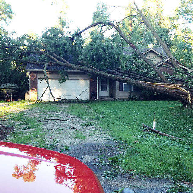
The twister hit at approximately 9:15 p.m., damaging a reported 16 homes, three incurring major damage, with minor or moderate storm damage to the others, according to the management assessment team of local volunteers.
The damage was reportedly confined to an area a mile or two east of the northeast corner of the lake.
An EF-1 is considered a weak tornado, according to the Enhanced Fjuita Scale, with winds typically from 86-110 mph.
As of 4:45 p.m. Tuesday, some portions of Heritage Lake were still reportedly without power.
Officials from the National Weather Service's Indianapolis office toured the Floyd Township area Tuesday afternoon and agreed with the assessment of Putnam County Emergency Management Agency weather specialist Chris Edwards who was out in the midst of the storm, observing such evidence as cloud rotation, debris patterns and trees being blown toward each other in the converging winds.
"Chris (Edwards) chases them (storms), he was right in the middle of a 74-mph wind gust he thought was going to blow him off the road," Capt. Russ Evans of the EMA and Community Emergency Response Team (CERT) told the Banner Graphic.
Edwards explained that he was west of Groveland on U.S. 36 when he encountered the same HP (high-precipitation) super cell that went on to produce the wall cloud and rotation that spawned the EF-1 tornado as it headed east.
Although his truck was brushed by a couple of falling trees, Edwards said he came away without any damage to the storm-chasing vehicle.
However, Edwards said he observed roof debris blown off structures west of Groveland and other debris about a half-mile southwest of Groveland, while north of there he spotted cornfields that "were just shredded" by the large hail typically associated with the north side of the wall cloud.
Where the storm first entered Putnam County, emerging near U.S. 231 and State Road 236, Edwards also witnessed minor tree damage, noting that it became "much thicker as the storm approached Groveland."
About thee inches of rain fell during the storm near New Winchester, Edwards said, reporting that he personally encountered the resulting flooding issues on U.S. 36. Water was running out of the fields so fast at that point, he said, it was up to the doors of his truck.
In the most heavily affected area, Edwards reported a "narrow path of where trees were just shredded and blown toward each other by the converging winds."
The storm that hit eastern Putnam County Monday night, Edwards said, was one of two super cells, the other developing near Lafayette and producing a tornado on the ground briefly in Warren County.
Evans, meanwhile, stressed that no one was injured during the storm as he praised volunteers from CERT and Floyd Township Fire Department personnel who cut trees and cleared roads of debris all night and into the morning.
"We were fortunate," Evans said. "People had plenty of warning and took the warning seriously.
"This puts an exclamation point on when we say, 'be prepared, be ready.'"
Observing the Floyd Township damage Tuesday, Evans said he saw numerous trees that were 3.5- to 4-feet at the base had just been pushed over by the wind and other trees still standing but stripped of their tops.
"But in the big picture," Evans said, "nobody lost a home. I saw just one house with a tarp on it."
He praised the CERT teams, which assembled in four teams of two, joining EMA Director Tom Helmer and Central Dispatch Director Dave Costin in assessing damage in advance of the National Weather Service team that confirmed the tornado.
"Our CERT teams got their feet wet last night," Evans said, no pun intended. "It's amazing to have 20 people come out at midnight and watch intersections and traffic so people don't drive into some area they shouldn't.
"It was just a great job by everyone."