
Chasing the storm not all fun and games
Chris Edwards has been fascinated by weather patterns for a long time. He spotted his first tornado in a field near his house when he was only 10 years old.
"I couldn't get him to come inside. He kept telling me to go get a camera," said his mother Robin Pickett. "He's been hooked ever since."
For 22 years, Chris has been spotting serious weather and reporting it to the National Weather Service (NWS). Over that period he has spotted 17 tornadoes that the NWS didn't know about.
"Anytime there is a thunderstorm I go out into it whenever I can," said Edwards. "I usually go in from the south. I've never been caught in anything too serious."
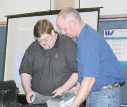
Edwards hosted a training session taught by Joe Nield with the NWS Wednesday evening. This class was all about the types of cloud formations to watch for, how to tell if serious weather could occur and staying safe as spotters.
"It's designed to teach you how to identify a tornado in order to help the weather service give more accurate warnings," said Edwards.
A wide range of topics is covered and the class is designed to help storm spotters learn what to look for, including intensity, tornado activity, cloud formations, hail and thunder and lightening.
"Indiana had its first tornado in January last year. Typically the severe weather season begins in late May and runs through mid June. Last year, we didn't see much activity. Indiana hasn't seen a class 4 or 5 tornado in quite a while. We're due, so get ready," said NWS Meteorologist Joe Nield to the room of over 30 people.
Nield told the group that changes were coming in the reporting of the size of hail from storms. In the past, hail the size of about a penny was reported to the weather service. Soon that size will change to hail that is one inch in diameter, or the size of a quarter.
"Hail is an important indicator of severe weather. The larger the size of hail generally, the more serious the storm," said Nield. "But all thunderstorms are dangerous. Eighteen hundred of them occur at any moment in the world. A thunderstorm is severe if it produces hail that is 3/4-inches in diameter (soon to change to 1-inch), winds of 58 mph or stronger or a tornado."
In order for a thunderstorm to form, it needs moisture, warm air that can rise rapidly and "lift," which is a cold or warm front that is capable of lifting air.
Tornadoes form when a change in wind direction and an increase in wind speed creates a horizontal spinning effect. Rising air within the thunderstorm updraft tilts the rotating air from horizontal to vertical. This rotation extends through much of the storm and this is where tornadoes form.
"Most tornadoes are weak ones, usually about 88 percent of all tornadoes. Strong ones have winds of 110-205 mph and cause nearly 30 percent of all deaths. Less than one percent are the really big ones, but they cause 70 percent of all tornado deaths," said Nield.
In the United States there is an average of 1,200 tornadoes a year, causing 70 fatalities and 1,500 injuries nationwide. More statistics about tornadoes can be found at www.spc.noaa.gov
The NWS uses Doppler radar to watch the sky. These instruments can detect increasing rotation and allow life-saving warnings to be issued before a tornado forms.
"The brighter the color the more severe the storm. The bright reds and greens need to be watched," said Nield. "But, radar doesn't always tell us if there is a tornado forming. That's why we need spotters."
The biggest problem with most tornadoes occurs when debris is picked up and tossed by the winds. If a tornado looks black it generally has debris in it.
"I've seen tornadoes that form when the sun is out. They look white because the light is shinning behind them," said Edwards.
Often after large hail has formed and rained down on the area, there will be a clearing, even sunshine.
"Look out when this happens, often there is a tornado coming right behind the hail and clearing," said Nield.
A lot of attention was given to the formation of clouds, including fronts, shelves and squall lines and super cells.
Straight-line winds are another danger of storms and are responsible for most thunderstorm wind damage. Winds can exceed 100 mph in these storms.
The class also covered the dangers of flooding and lightning as well as the importance of staying safe for spotters.
"More people are killed in floods and flash floods than any other natural disaster. Most of those occur in vehicles," said Nield.
Those at most risk from thunderstorms are people who are outdoors, especially under or near tall trees, water or on hilltops. Flash flooding dangers exist for anyone who walks or drives through floodwater. Tornado risk is highest for people in mobile homes and automobiles.
The NWS is always looking for help in spotting storms. They provide training like the session presented Thursday evening.
Information gathered by storm chasers is sent to the National Weather Service by email or phone. For information about NWS go to the Web site at www.weather.gov/ind
Anyone interested in helping spot storms in Putnam County can call Edwards at 765-720-8650. Training will be provided.