
Tuesday tornado touchdown confirmed near Cloverdale
CLOVERDALE -- The warnings weren't all for naught. While no major damage was reported in Putnam County, the storm cell that moved through the area Tuesday evening produced three tornadoes, one of which touched down southeast of Cloverdale.
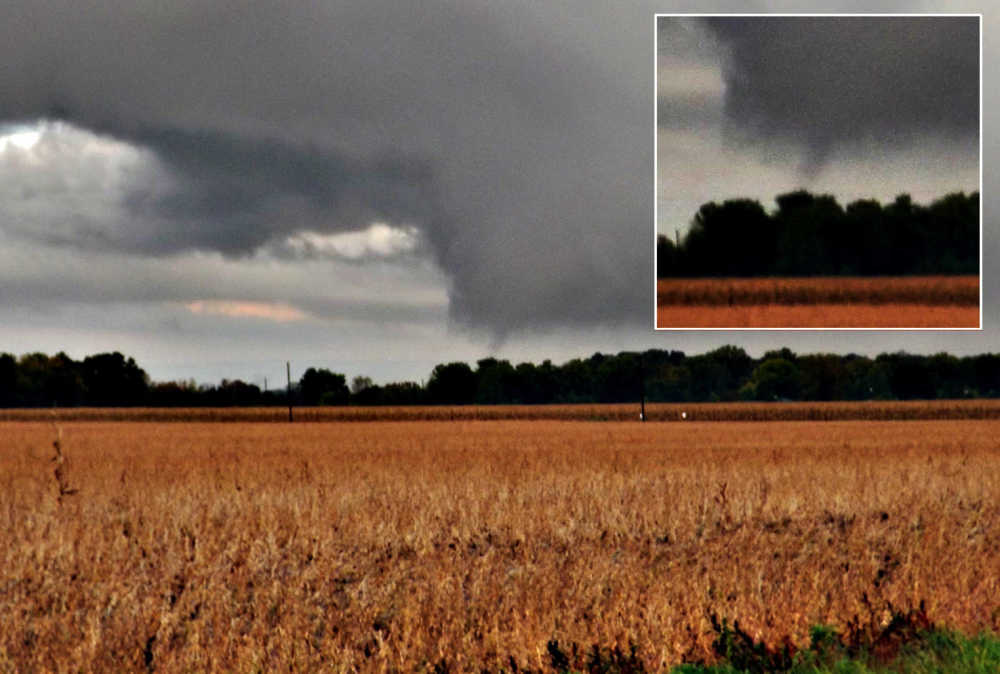
This according to Putnam County Emergency Management Severe Weather Specialist Chris Edwards, who told the Banner Graphic an EF-0 (zero) tornado touched down 0.2 miles south of State Road 42 and about one mile east of U.S. 231 Tuesday evening.
As Edwards continued to move east on the state road, the storm moved southeast, farther and farther from his vantage point.
The storm, a low-top super cell, tracked into Putnam County from Parke County, moving southeast. Edwards tracked it for about 45 minutes, from north of U.S. 40 in Washington Township to south of State Road 42 in Cloverdale Township.
The first and longest-lived tornado occurred a few minutes before 7 p.m., touching down for 10-15 seconds. Taking place in a disked cornfield, the event caused very little damage beyond taking out a couple of tree limbs at the edge of the field.
From this point, the storm continued southeast toward Paragon in Morgan County. As the storm moved farther away from him, Edwards noted two more touchdowns, each one 6-10 seconds in duration. From his location, Edwards said it was unclear if the latter two tornadoes took place in Owen County or Morgan County.
The described all three tornadoes as "very short-lived, diffused funnels that reached the ground."
Edwards returned to the area Wednesday morning with National Weather Service representative Dave Tucek, who confirmed the first touchdown as an EF-0 tornado. Edwards and Tucek confirmed it ws on the ground for about 0.1 mile and had a diameter of 50 yards.
Despite their search, the duo could not confirm the second and third touchdowns. Given their short duration and relative lack of wind power, Tucek told Edwards finding evidence of them "would be like finding a needle in a haystack."
Although the county escaped without serious damage, the troubling element of the storm was that it came with little advance notice. No tornado watch was issued by the National Weather Service, with conditions instead moving from no advisory level directly to a tornado warning, which indicates the public should take immediate shelter.
Emergency Management Public Information Officer Russ Evans said this should serve as a reminder for the public to be ever vigilant to changing weather conditions.
"The public needs to remember how quickly things can turn bad, even when no tornado watch is in effect," Evans said. "The storms developed and spun up a tornado in just a matter of minutes.
"This should serve as a very, very strong reminder of how Mother Nature can turn on us in a hurry. Folks should always be prepared to take shelter."