
Another Saturday, another snowstorm headed for Indiana
Hoosiers are likely to feel the wrath of winter for the second straight weekend as another winter storm bears down upon the area with a Winter Storm Watch issued for much of west-central and central Indiana from Friday night through Saturday night.
The National Weather Service expects snow to spread across the area Saturday morning with the possibility of freezing rain mixing with snow just south of Interstate 70.
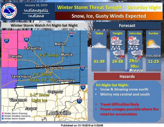
Weather forecasters have yet to pinpoint how much snow this latest storm might produce but models run by the National Weather Service Prediction Center include a high probability of snowfall of four inches or greater occurring across much of Indiana.
Snowfall potential on a line from Terre Haute through Indianapolis to Richmond falls in the three- to five-inch range with higher amounts possible in isolated areas. North of that line, snowfall potential increases with amounts in the four- to six-inch range possible.
Compounding the nature of the storm this weekend will be strong winds with gusts of 30 to 40 mph expected.
The coldest air of the season comes in on Sunday as an arctic blast arrives, dropping temperatures in the low teens Sunday with lows expected to fall below zero Monday morning and windchills likely well below zero.