
First measurable snow really not that early
While Saturday�s first snowfall of the season may have seemed a bit early, it was really pretty much right on time in central Indiana.
The fact Hoosiers endured three seasons in three days -- 70 degrees on Thursday, followed by the 50s on Friday and a snowy Saturday -- made it seemed that much more unusual.
The average date of the first snowfall in central Indiana is Nov. 19, according to the National Weather Service. The earliest snow has arrived in the area was Oct. 18 in 1989.
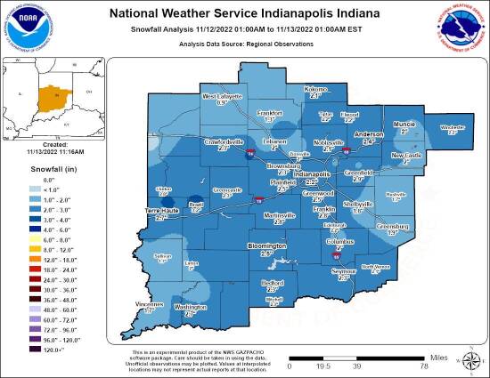
Saturday�s snow produced 2.3 to 3 inches of snow across most of Putnam County, while 3.3 inches was reported in Brazil and 2.6 inches in Crawfordsville.
Here�s a list of the first measurable snowfalls for central Indiana in the last 10 years:
� 2021 -- Nov. 14.
� 2020 -- Dec. 16.
� 2019 -- Nov. 11.
� 2018 -- Nov. 14.
� 2017 -- Dec. 9.
� 2016 -- Dec. 13.
� 2015 -- Nov. 21.
� 2014 -- Oct. 31.
� 2013 -- Nov. 11.
� 2012 -- Nov. 12.
Central Indiana averages 25.5 inches of show for the winter season and 21.2 for meteorological winter (December-January-February).
The last seven seasons have been below normal, the Weather Service reports, at:
� 2021-22 -- 9.5 inches.
� 2020-21 -- 22.2 inches.
� 2019-20 -- 13.3 inches.
� 2018-19 -- 9.7 inches.
� 2017-18 -- 23.2 inches.
� 2016-17 -- 19.4 inches.
� 2015-16 -- 13.3 inches.